In May of this year, Missouri governor Mike Parson signed a bill that has changed the boundaries of the state’s eight congressional districts. This revision has brought about some controversy – so what’s the big deal?
Each of Missouri’s districts is represented by a member of the United States House of Representatives. The way the boundaries between congressional districts are drawn can influence the way that resources are distributed, and what representatives are likely to be elected. In simpler terms, too many “splits” over the years can make it increasingly harder to have a voice in your government. Gerrymandered districts historically protect incumbents and the current district map makes our two party system ineffective. The republican party controls the district maps and have drawn them once again to favor republican candidates.
I try to avoid politics in my law practice, but I can’t ignore the facts. In 2005, the republicans controlled the legislature and governor, and they changed our law in ways that hurt injured workers especially and injury victims in general, shifting a lot of power to insurance companies.
According to the Missouri Independent, Governor Parson disparaged members of the Senate who were against the map revision at the press release of the bill signing. Below is a direct excerpt.
“This past session, we saw a few individuals’ political posturing obstruct key pieces of priority legislation and promote inefficient and ineffective government,” Parson said. “It’s unfortunate so much time and productivity were lost just to receive a map with the same partisan split that was proposed six months ago.”
Others have a different perspective on the matter. On May 31rst, the Missouri House of Representatives voted to reject the new map and requested that the Senate allow a conference to work out the kinks. According to an article that appeared in U.S. News, Republican Senator Bob Onder said:
“The House vote today was a vote for the liberal activist courts to draw the map. We’re not going to conference.”
There has been quite a bit of “back-and-forth” on the map leading up to, and even after the signing of the bill. There have been murmurs of lawsuits, but for the moment it seems the new boundaries are going to stick.
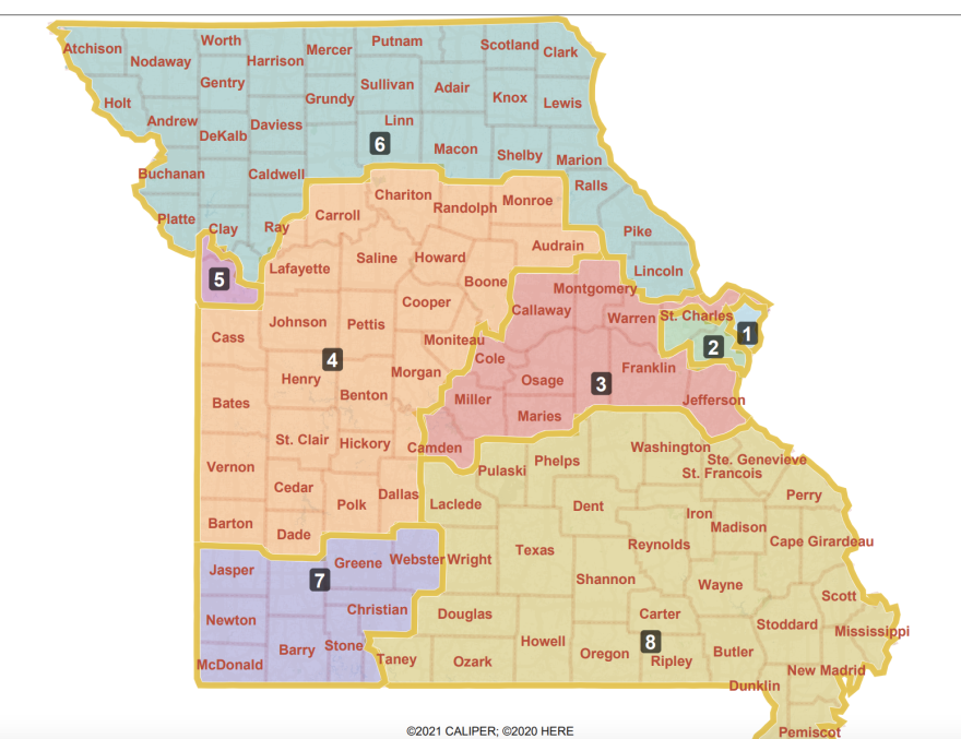
Now that the map has officially been updated, here is a rough description of the new districts.
- For the first district, Louis and northern St. Louis County have had its boundaries extended and now include Bridgeton, more of Maryland Heights, Clayton, Richmond Heights and Creve Coeur. This consolidates votes from traditionally democratic party voters and makes other districts less competitive between the parties.
- The second district contains the remaining sections of St. Louis County, with Warren County south of I-70. Now, Franklin County has been added from the 3rd District. The portion of St. Charles County in the district now extends to the Warren County line, primarily along Interstate 64 and I-70.
- The third district stretches from central Missouri up to the Mississippi River. Cooper County, Moniteau County, and the southern half of Boone County have been moved in from the fourth district. Crawford and Washington counties have been moved in as well from the 8th District. Lincoln County was removed and placed in the 6th District. The district now includes the western half of the county instead of northern Jefferson County.
- From central Missouri west to the Kansas border along and south of the Missouri River is the fourth district. Cooper, Moniteau and half of Boone County have been relocated to the third District, while Randolph County and part of Audrain County were shifted to the 6th District. Part of eastern Jackson County, and Lafayette and Saline counties were taken from the 5th District, and so was Polk County from the 7th District.
- The fifth district has lost its rural counties of Lafayette, Saline and Ray. In addition, the boundaries outside of Kansas City in Jackson and Clay counties have shifted to include Lee’s Summit and eastern Blue Springs, again removing traditionally democratic voters and making other districts less competitive.
- The sixth district is physically the biggest. In northwest Missouri it now covers the majority of the area located north of the Missouri River, including all counties except for those adjacent to the river in northeast Missouri. Voters in Ray, Randolph, Audrain, and Lincoln counties are new to the district.
- In the seventh district, the boundaries are unchanged except for one shift. Polk County is now a member of the 4th District and includes more of Webster County.
- The eighth district now includes more of Jefferson County and no longer contains Crawford and Washington counties.
You can learn more about how congressional districts work, and what you can do about it if you so choose, here. By making districts less competitive between the parties, the new maps unfairly solidify the republican hold on state government and influence our federal elections as well.
The world is ever changing, including the state of Missouri. Continue to keep up with the times by checking our legal blog. Remember to write to your representatives about any concerns you have in terms of your community and government. You can find important contact information here.
Your voice matters!